 Lýsigagnagátt
open data
Type of resources
Available actions
Topics
INSPIRE themes
Keywords
Contact for the resource
Provided by
Years
Formats
Representation types
Update frequencies
status
Scale
-

Samsettar og uppréttar sögulegar loftmyndir af Íslandi. Unnið er að því að staðsetja loftmyndir frá 1974 og 1994 – 2000 úr loftmyndasafni Landmælinga Íslands (https://gatt.lmi.is/geonetwork/srv/ice/catalog.search#/metadata/d2323e18-ab9f-495d-8a4e-58c2a5fb096e ). Myndirnar eru birtar jafnóðum og búið er að staðsetja þær en ætlunin er að staðsetja eldri myndir síðar. Svæði af myndum sem teknar voru í sama flugi og úr sömu flughæð eru sett saman. Upplausn myndanna er yfirleitt 50 cm. Búið er að vinna myndirnar með sjálfvirkum aðferðum. Ákveðnar staðsetningar eru valdar af gervitunglamyndum (https://gatt.lmi.is/geonetwork/srv/ice/catalog.search#/metadata/e542c260-6431-48a5-8065-93350b8cb3a1) og stilltar af á ÍslandsDEM landhæðalíkaninu (https://gatt.lmi.is/geonetwork/srv/ice/catalog.search#/metadata/e6712430-a63c-4ae5-9158-c89d16da6361 ). Gerð eru nákvæm landhæðalíkön úr sögulegu loftmyndunum þar sem hæðarnákvæmni er yfirleitt innan við 1 m. Líkönin eru síðan notuð til að staðsetja loftmyndirnar. Áætluð staðsetningarnákvæmni myndanna er minna en 2 m. ---------------------------------------------------------------------------------------------------------------- This repository includes orthorectified and mosaicked historical aerial images from all over Iceland. The datasets are created from historical aerial images on film from the years 1974, 1994 - 2000 from the aerial photograph collection of the NLSI (https://gatt.lmi.is/geonetwork/srv/ice/catalog.search#/metadata/d2323e18-ab9f-495d-8a4e-58c2a5fb096e). Each mosaic is created from images taken on the same day at approximately the same height. The resolution of the mosaics is usually 50 cm. The historical photographs have been processed using automated methods of detection of points of interest (control points?) using the Maxar mosaic (https://gatt.lmi.is/geonetwork/srv/ice/catalog.search#/metadata/e542c260-6431-48a5-8065-93350b8cb3a1)) followed by a refined correction of the cameras using the IslandsDEM (https://gatt.lmi.is/geonetwork/srv/ice/catalog.search#/metadata/e6712430-a63c-4ae5-9158-c89d16da6361) as reference. For each block of historical photographs, an accurate Digital Elevation Model (DEM) is created (where the vertical accuracy is typically better than 1 m), which is used to orthorectify the aerial photographs. The estimated horizontal accuracy of the orthorectified aerial imagery is better than 2 meters.
-

Röð uppréttra loftmynda úr loftmyndasafni Landmælinga Íslands sem unnar voru á árunum 2013 til 2018 hjá Jarðvísindastofnun HÍ, sem partur af tveimur verkefnum: 1 - Mælingar á jöklabreytingum úr sögulegum loftmyndum. Þetta verkefni var unnið af Joaquín M.C. Belart í M.Sc. og Ph.D. hjá Jarðvísindastofnun. Útvaldar loftmyndir frá 1945 til 1994 voru skannaðar hjá Landmælingum Íslands sérstaklega fyrir þetta verkefni. Vinnsla þessara loftmynda fór fram með því að nota "Ground Control Points" (GCP) sem teknir voru úr lidarmælingum á íslenskum jöklum. Úrvinnsla gagna úr Drangajökli fór fram með ERDAS hugbúnaðinum. Nánari upplýsingar um vinnsluna er að finna í Magnússon o.fl., 2016 (https://tc.copernicus.org/articles/10/159/2016/tc-10-159-2016.html). Úrvinnsla gagna frá öðrum jöklum var unnin með MicMac hugbúnaðinum, einnig með GCP teknir af lidar. Nánari upplýsingar um vinnsluna eru fáanlegar í Belart o.fl., 2019 (https://www.cambridge.org/core/journals/journal-of-glaciology/article/geodetic-mass-balance-of-eyjafjallajokull-ice-cap -for-19452014-processing-guidelines-and-relation-to-climate/9B715A9E0413A6345C2B151B1173E71D) og Belart o.fl., 2020 (https://www.frontiersin.org/articles/10.31630/feart/full.316390/feart. 2 - Mælingar á hraunmagni Heklugosanna á XX öld. Þetta verkefni var unnið af Gro B.M. Pedersen sem hluti af verkefni þar sem unnið var að umhverfiskortlagningu og vöktun Íslands með fjarkönnun "Environmental Mapping and Monitoring of Iceland by Remote Sensing" (EMMIRS, fjármagnað af Rannís) á árunum 2015-2018. Loftmyndirnar af Heklu frá 1945 til 1992 voru skannaðar af Landmælingum Íslands. Vinnsla þessara mynda var gerð með ERDAS hugbúnaðinum og nánari upplýsingar um vinnsluna er hægt að nálgast í Pedersen o.fl., 2018 (https://agupubs.onlinelibrary.wiley.com/doi/full/10.1002/2017GL076887) --------------------------------------------------------------------------------------------------------------- A series of orthomosaics using the archives of aerial photographs from Landmælingar Íslands (Loftmyndasafn) created between 2013 and 2018 at the Institute of Earth Sciences, as part of two projects: 1 - Measurements of glacier changes from historical aerial photographs. This project was conducted by Joaquín M.C. Belart during his M.Sc. and his Ph.D. at the Institute of Earth Sciences. A selection of aerial photographs from 1945 to 1994 were scanned at Landmælingar Íslands specifically for this project. The processing of these aerial photographs was done using Ground Control Points (GCPs) extracted from lidar surveys of Icelandic glaciers. The processing of the data from Drangajökull ice cap was done using the ERDAS software. Further details on the processing are available in Magnússon et al., 2016 (https://tc.copernicus.org/articles/10/159/2016/tc-10-159-2016.html). The processing of the data from other glaciers was done using the MicMac software, also with GCPs extracted from lidar. Further details of the processing are available in Belart et al., 2019 (https://www.cambridge.org/core/journals/journal-of-glaciology/article/geodetic-mass-balance-of-eyjafjallajokull-ice-cap-for-19452014-processing-guidelines-and-relation-to-climate/9B715A9E0413A6345C2B151B1173E71D) and Belart et al., 2020 (https://www.frontiersin.org/articles/10.3389/feart.2020.00163/full) 2 - Measurements of the lava volumes of the Hekla eruptions in the XX century. This project was conducted by Gro B.M. Pedersen as part of the Environmental Mapping and Monitoring of Iceland by Remote Sensing (EMMIRS, financed by Rannís) project between 2015-2018. The aerial photographs of Hekla from 1945 to 1992 were scanned by Landmælingar Íslands. The processing of these photographs was done using the ERDAS software, and further details of the processing are available in Pedersen et al., 2018 (https://agupubs.onlinelibrary.wiley.com/doi/full/10.1002/2017GL076887) References: Belart J.M.C., Magnússon E., Berthier E., Pálsson, F., Aðalgeirsdóttir, G., & Jóhannesson, T. (2019). The geodetic mass balance of Eyjafjallajökull ice cap for 1945–2014: Processing guidelines and relation to climate. Journal of Glaciology, 65(251), 395-409. doi:10.1017/jog.2019.16 Belart J.M.C., Magnússon E., Berthier E., Gunnlaugsson Á.Þ., Pálsson F., Aðalgeirsdóttir G., Jóhannesson T, Thorsteinsson T and Björnsson H (2020) Mass Balance of 14 Icelandic Glaciers, 1945–2017: Spatial Variations and Links With Climate. Front. Earth Sci. 8:163. doi: 10.3389/feart.2020.00163 Magnússon, E., Belart, J.M.C., Pálsson, F., Ágústsson, H., and Crochet, P.: Geodetic mass balance record with rigorous uncertainty estimates deduced from aerial photographs and lidar data – Case study from Drangajökull ice cap, NW Iceland, The Cryosphere, 10, 159–177, https://doi.org/10.5194/tc-10-159-2016, 2016. Pedersen, G. B. M., Belart, J. M. C., Magnússon, E., Vilmundardóttir, O. K., Kizel, F., Sigurmundsson, F. S., et al. (2018). Hekla volcano, Iceland, in the 20th century: Lava volumes, production rates, and effusion rates. Geophysical Research Letters, 45, 1805–1813. https://doi.org/10.1002/2017GL076887
-
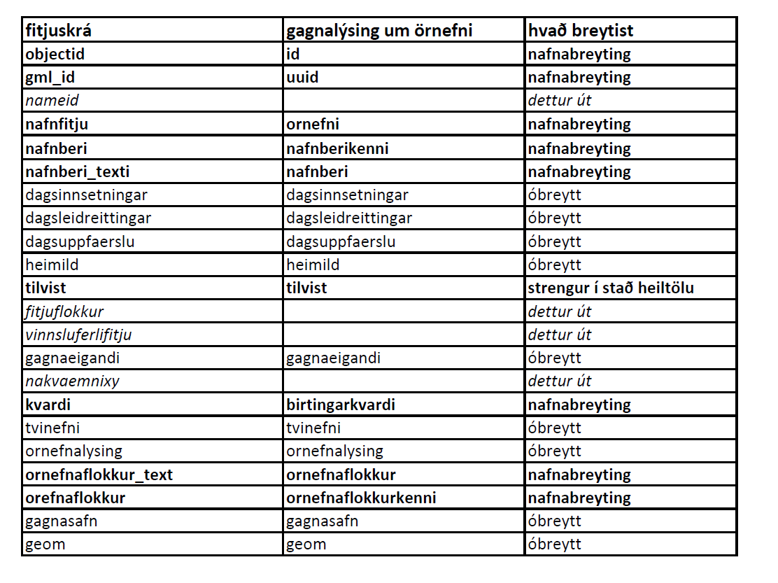
Örnefni eru í þremur lögum: flákalag, punktalag og línulag. Uppfærð örnefni birtast vikulega í vefsjám.
-

Valdar breytur úr Manntalinu 2021 eru teknar saman fyrir 1 km² reiti í Reitakerfi Íslands. Breyturnar eru valdar samkvæmt Reglugerð ESB nr. 1799/2018. Öllum eru heimil afnot af efni Hagstofunnar en geta skal heimildar. ------------------------------------------------------------------------------------------------------------------ Selected characteristics from the Icelandic Population and Housing Census 2021 presented in the Inspire compatible Icelandic Grid System (1 km²). The breakdowns are in line with the Commission Implementing Regulation (EU) 2018/1799 of 21 November 2018 on the establishment of a temporary direct statistical action for the dissemination of selected topics of the 2021 population and housing census geocoded to a 1 km² grid (OJ L 296/19, 22.11.2018). Please quote the source.
-

Gögnin sýna útlínur hrauns frá Heklugosunum árin 1947-1948, 1970, 1980-1981, 1991 og 2000 af uppréttum loftmyndum sem teknar voru eftir hvert eldgos. Nánari upplýsingar er að finna í grein Pedersen o.fl., 2018 (https://agupubs.onlinelibrary.wiley.com/doi/full/10.1002/2017GL076887) Tilvísun: Pedersen, G. B. M., Belart, J. M. C., Magnússon, E., Vilmundardóttir, O. K., Kizel, F., Sigurmundsson, F. S., et al. (2018). Hekla volcano, Iceland, in the 20th century: Lava volumes, production rates, and effusion rates. Geophysical Research Letters, 45, 1805–1813. https://doi.org/10.1002/2017GL076887 ---- The lava outlines from the eruptions of Hekla in 1947-1948, 1970, 1980-1981, 1991 and 2000, digitized from orthorrectified aerial photographs acquired after each eruption. Details of these data are available in Pedersen et al., 2018 (https://agupubs.onlinelibrary.wiley.com/doi/full/10.1002/2017GL076887) Reference: Pedersen, G. B. M., Belart, J. M. C., Magnússon, E., Vilmundardóttir, O. K., Kizel, F., Sigurmundsson, F. S., et al. (2018). Hekla volcano, Iceland, in the 20th century: Lava volumes, production rates, and effusion rates. Geophysical Research Letters, 45, 1805–1813. https://doi.org/10.1002/2017GL076887
-

Mósaík af Hexagon KH9-PC myndum frá 22. ágúst 1980 - fyrstu niðurstöður. Um er að ræða fyrstu útgáfu af myndum sem teknar voru 22. ágúst 1980 af Hexagon KH9 könnunargervihnettinum. Myndirnar voru teknar með panorama myndavél (PC) sem náði að taka myndir af um 75% af Íslandi á einum degi með staðbundinni upplausn á bilinu 0,7 til 1,4 metrar. Opnað var á gögnin árið 2013 og er hægt að hlaða þeim niður frá Jarðfræðistofnun Bandaríkjanna (USGS: https://earthexplorer.usgs.gov/). Filmurnar voru skannaðar af USGS í 7 míkron upplausn árið 2023. Geometría skynjarans er ekki þekkt og myndirnar eru mjög bjagaðar. Vegna þessa er vinnsla þessara gagna tilraunakennd. Ames StereoPipeline v3.3 (https://zenodo.org/record/8270270) var notuð til að vinna Hexagon KH9 myndirnar. Í fyrstu niðurstöðum eru verulegar staðsetningarvillur og því þarf að nota þessi gögn með fyrirvara. Sem dæmi má nefna að það er u.þ.b. 2 km tilfærsla á höfuðborgarsvæðinu til austurs. Almennt séð er staðsetningin betri (rýmisnákvæmni upp á tugi metra) í miðhluta myndanna en brenglun er meiri á austur- og vesturhlið myndanna. Vinsamlega hafið samband við Landmælingar Íslands til að fá nánari upplýsingar. ---- This mosaic is the first version of the processing of a set of images acquired on the 22nd August 1980 from the reconnaissance satellite Hexagon KH9, and specifically, from its panoramic camera (PC), which acquired about 75% of Iceland in one day, with a spatial resolution between 0.7 and 1.4 meters. The data was declassified in 2013 and is available for download through the United States Geological Survey (USGS: https://earthexplorer.usgs.gov/). The films were scanned by the USGS at 7 micron resolution in 2023. The geometry of the sensor is not known, and the images contain large distortions, therefore the processing of these data is highly experimental. We used the Ames StereoPipeline v3.3 (https://zenodo.org/record/8270270), with the suggested workflow for processing Hexagon KH9 images. The first results have significant positional errors and therefore these data needs to be used with special caution. For example Reykjavík greater area has a ~2 km shift to the east. In general, the location is better (spatial accuracy of tens of meters) in the middle part of the images, and distortions are larger on the East and West sides of the images.